Tuesday, August 26, 2014

Will do laps of Grouse Grind for charity!

I don't ask for much, in fact I hardly ever ask for anything at all.
But this time I'm asking you - no I'm begging you to help me help the Golder Trust for Orphans.
It's simple really.
You donate money (small amounts, large amounts, pennies, nickels, quarters, dimes, pocket lint).
The more money I raise - the more laps I do. For every additional $50 raised I will do an extra lap of the grind!
I'm not asking you to donate the full $50 yourself, unless you would like me to loathe you as I do a lap of the grind in your honour, purely because you're such a kind, generous individual....

In all honesty - Take a look at the amazing things the Golder Trust for Orphans does to improve the quality of life of children who have been orphaned or displaced by the AIDS pandemic.


The Trust, which is funded mainly by contributions from Golder’s operating companies and Golder staff, provides financial support to NGO’s caring for and counselling families and dependents of people living with HIV/AIDS. The Golder Trust for Orphans supports NGO’s and other organisations of all religions and ethnic groups. The primary focus is in Africa, with a vision to one day support projects all over the world.

When you're convinced that your money is going to a great cause, and as a bonus will cause me to endure another lap of the grind (named by Outside magazine as one of the world's most dangerous hikes, might I add) then donate, donate, donate! And pass it on!

Donations can be made securely through paypal here:
http://www.youcaring.com/other/jenna-bowling-g3challenge-2014/220266

Help me keep on running :)

J.B. Running

Thursday, August 21, 2014

A Fat Dog's Tale

It's Saturday August 16th at 4:45 in the morning. I wake up to my alarm blasting beside my head, hit the snooze button and snuggle back into my sleeping bag. Ten minutes later my alarm goes off again, I can hear Chris' family drag themselves out of the tent, and I know I have to do the same.
I finally muster up the courage to go out in to the cold and brave the day I'd known was coming for almost a year. I can't believe it's finally race day!

Foggy start to the FatDog70 up Blackwall Peak
It's now 7:00 am and Brad and I are loaded on the bus heading up to Blackwall Peak. It's warm enough outside to be in shorts and a shirt. We're hopeful the weather will hold and it does - sort of. We unload from the bus in the mist/fog/clouds to temperatures that have our teeth chattering, sending everyone scrambling for their jackets. After a short wait, we're off and running straight out into the alpine meadows. Although I know from training runs its absolutely beautiful up there, it was difficult to see more than a few meters away. It made for a pretty eerie start to the race!
I didn't make it far before I was hungry, since I always have trouble eating before a big race. Despite eating constantly, this hunger would plague me for the next 20 miles.
Let me just put this out there now... I'm not a strong starter. The first 20 miles was a mix of excitement that I was finally out doing the race and fear that I would get lost or run out of food.
About 5 miles in I was already on my own. I couldn't see far enough ahead to spot other runners, and I had no idea if there was anyone behind me. Though my legs were feeling good, I was rather tired and a little concerned as I'd already eaten half my food. I slogged through the next 20 miles, running where I could and walking pretty much every slight incline. By the time I made it to the first aid station (Cayuse flats), I had already had dangerous thoughts of failing at least 50 times.
Coming into Cayuse flats was one of the most motivating parts of the race. I had my watch on the minute gps recording intervals, so I came into the aid station 2 miles sooner than expected (according to my watch distance). My race crew (aka my family) was there to get me fed and back out on the course. I'm not sure what changed at that point, but I left Cayuse feeling like a whole new person. There are some nasty hills through the section between Cayuse and Cascade Aid Station that I powered through feeling rather fantastic.
The next section has a lot of aid stations close together, which was a blur of eating all the food I could stomach, and getting attacked by bug spray (thanks mom!). We also got to put on fancy safety vests and run on the highway for a bit which was fun!
Coming in to Shawatum aid station at mile 40
After Summallo Grove comes a flat section with nothing too exciting; I was feeling energized from all of the aid stations so there wasn't much to complain about. At this point the sun was out and it was glorious sweaty running along rolling hills. Though the flattest section before Shawatum aid station seemed to drag on forever, I finally made it back to my wonderful crew who fueled me up and sent me packing.
The next section was the only part of the racecourse I hadn't seen, which had me a little concerned. I'd been out on the trail for 10 hours by now, but I knew in 10 miles I'd have a pacer to drag me the last 20 , which was pretty darn motivating! The highlight of this section had to be the song that wouldn't leave my head, something like "walking on the trail with candy, walking on the trail with candy". Intelligent, eh? When I got bored of singing about my candy, I pulled out my mosquito net.  I was actually digging in my pack for electrolyte tablets, but decided I'd put it on the mozzy net and see if it helped. There were a few mosquitos buzzing in my ear - so it really couldn't hurt. This is when I knew I'd been running for too long, because I really don't know if it helped with the mosquitos, but it sure was a lot of fun. It added a new jungle like element to my vision that spiced things up a little. Though it did make it harder to eat candy.
I made it to the 50 mile mark (Skyline Aid), and was now excited knowing that despite the rather crappy start I could still make the full distance. I picked up my cousin - the BEST pacer in the world - grabbed my poles, and set out up the hill to break things! Yes, break things. But we'll get to that. Up until Skyline Aid I had been ignoring my pace chart completely, but I had the general feeling I was going pretty darn slow. Apparently, I was actually on pace for a 26 hour race (the cutoff being 27, my goal being 24), but thankfully nobody told me that.
I'd grabbed my poles at the last major aid station (Skyline) to help me get up and down the insane mountainous terrain that is the last 20 miles. Lucky for me, about 20 minutes in, the strap on my pole snapped, leaving me with a nice bracelet. A girl needs to feel pretty 50 miles in, right? The pole itself still worked just fine so we kept on truckin'. The next few hours are a blur of climbing uphill and stuffing down candy as darkness descended upon us. After 3+ hours of climbing in the dark we reached the descent into one of the remote aid stations - Camp Mowich.
I sat down to have some broth while the aid station crew filled my pack. A few minutes later I put my pack back on, and immediately tossed it right off. It was soaked! Of course my bladder was leaking. So we pulled out the bladder only to find a lovely little pinhole happily spouting out water. Nothing a little duct tape couldn't fix. A few minutes later I was all duct taped and ready to hit the trail.
And then I fell apart. It was about midnight, I was dead tired, sick of eating, overheating, and I felt like I could pass out any minute. Doing what any sane (ha!) person would do, I stopped and told my cousin we had to go back to the aid station - that I was too tired and I needed to sleep. She wasn't quite as convinced on heading back, as we had already hiked 15+ minutes uphill from the aid station. So she pulled out a garbage bag, sat me on the trail, and got me to eat and drink and recover for a few minutes. Shaking and still feeling like crap, I made the decision to go back to the aid station. So we started to hike back down the hill, stopping every 2 minutes because I wasn't entirely convinced I wanted to go back, and because I was feeling a little better. So after a quarter mile adventure back towards the aid station we again turned around and decided to trek the 8k to Sky Junction, where I could take a nice nap before continuing.
This was the hardest 8k I have ever done! I didn't want to eat, but if I didn't eat I started to feel sick so I had to eat. I battled this the whole race, but the waves of nausea and near loss of consciousness made it that much harder. So I kept moving forward, and eating, and drinking to stay awake. I don't suggest hydration as a means of staying awake, because I was overhydrated for the next 21k to the finish. I have to admit that having to pee every 5 minutes is a rather great way of staying awake on the trail, though its not very helpful for running.
We finally made it to Sky Junction. I had no idea what time it was nor did I care. They asked what I wanted and I said I needed a nap. I can't tell you how thankful I am that Peter (the assistant race director) was at that aid station. He sat me down on a nice ledge covered with a space blanket, handed me a giant can of pringles and refilled my leaky pack. He got me to put my music in, and pretty much just forget about everything. I'm not really proud to say this, but it took me 40 minutes to get myself off that ledge and muster up the strength to continue. If I wasn't getting cold I don't think I would have left. It also helped that it's further to hike out at this point than finish.
Now comes the fun part! It's 2am. I've finally dragged myself out of the aid station, and I'm on the top of a mountain singing - terribly, I might add. My pack is still leaking. It's duct taped, but there's a little too much water in it this time. So I spent the last 13k getting progressively soaked as my pack leaked all over me, and I had to stop to pee every 5 minutes. Have I sold you on how much fun I was having yet? BUT I MADE IT!
We finally came down the last hill into lightning lakes and the trail was lit with glow sticks to the finish line and it was incredible!! I crossed the finish line wet and cold at 4:30 in the morning - 4.5 hours faster than my predicted time after leaving skyline aid station at mile 50! My final finish time was 21h29m55s

Check out my awesome 'Fat Dog' pj's I won!
The most important part of this post is to say THANK YOU! First to the amazing volunteers and people at Mountain Madness who made this an INCREDIBLE race! The course was so well flagged you couldn't get lost, the aid station crews were always smiling, there wasn't a thing I could find to complain about!
Next to Chris for dragging me on all those training runs and never getting tired of me!
My family for all coming out to support me as my crew and pacer!
And of course all of my friends and family who had to listen to me talk endlessly of our running adventures/Fat Dog/how messy our house was!

You are all amazing and I would not be a Fat Dog without you!

J.B. Running

Thursday, August 7, 2014

FatDog120 Course Maps

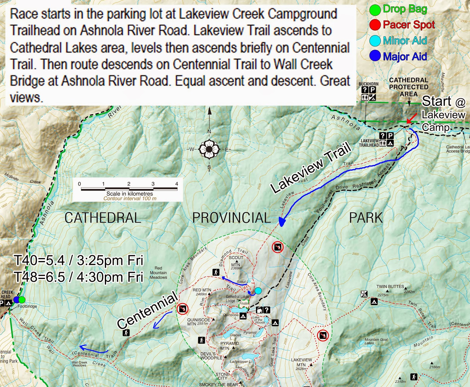
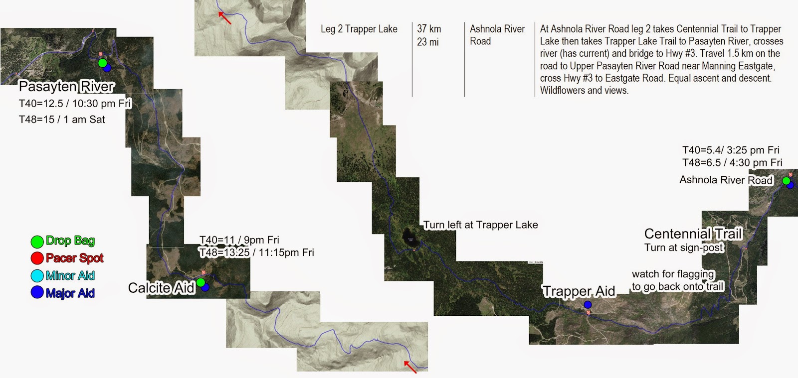
These maps of the FatDog race course may be of some help during the race. I've included aid stations etc so you know what to expect at each location. Some portions of the course (Leg 2 specifically) didn't have trail maps available so I had to use satellite/topo maps.
Major Aid stations have approximate checkpoint times (hours, time of day) indicated by T40 (for a 40 hours finish) or T48 (for a 48 hours finish). Hard cut-offs are indicated by C.
Each image below links to a higher quality one you can download.
FatDog120 Race Course Trail Map
Leg 1 trail map from Lakeview Creek Campground to Ashnola River Road
FatDog120 Race Course Trail Map
Leg 2 route map from Ashnola River Road to Pasayten River; potentially wet and squishy around Trapper Lake

FatDog120 Race Course Trail Map
Leg 3 and 4 from Bonnevier to Heather to Cascade Aid Station
FatDog120 Race Course Trail Map
Leg 5 trail map from Cascade to Shawatum to Skyline 2 trailhead. This is the buggiest section.
FatDog120 Race Course Trail Map
Leg 6 of the FatDog120 race course from Skyline 2 trailhead to the finish at Lightning Lakes Day Use Area

Tuesday, July 29, 2014

The last big hill climbed before FatDog!

This past weekend we headed back out to Manning Park to see the final 13 miles of the FatDog race course. We started Saturday morning with the goal of heading from our campsite at lightning lakes up Skyline to Camp Mowich and back. We were accompanied by Chris' mom and dad, who will be taking on the 30 mile and 70 mile course with us in August!

The rough uphill start leaves me in the dust while the Cochrane rabbits fly up it. My calves are burning, my heart is racing - and I can't help but feel like after all the training we've done I should be able to get up this hill without much trouble.
Camp Mowich - don't count on there being snow for the race!
After a 6 mile uphill warm-up I was finally able to run at a decent pace. Little did I know this tough start followed by a rather miraculous recovery would earn me the title of running like a "wounded possum". Thanks Brad & Sue!
I'm not sure whether this title was well deserved, or they were just dehydrated and delusional as the sun was beating down on us for 6+ hours!

After racing over a few slightly terrifying false peaks (because the first uphill was clearly not enough), we pranced through glorious alpine meadows and straight down the valley into Camp Mowich.

On the way back I came to see why last year's finishers crossed the line cursing those false peaks! If the climb from Skyline to Camp Mowich isn't enough - those false peaks are sure to knock your socks off.
On the bright side, the uphill I cursed at the start is actually quite a nice non-technical downhill.
Once we made it safely back to the campsite we decided to head back out around lightning lakes and part-way up frosty mountain to round out the mileage for the day. Chris ended up with 30 miles and 2400m climbing, while I stopped at a nice mountain marathon.

On Sunday we headed up Frosty Mountain for an easy (ha!) 26k loop. We started out tired and slightly sunburnt from Saturday's adventure. Of course, when I say slightly sunburnt I mean I had to borrow a hat and compression socks from Brad to make sure the sun never saw my skin again. Thank you!!!
I'm not sure how I survived this run, or why I agreed to go. This was not the first time we'd gone up Frosty, but I somehow managed to forget just how far 1300 m of climbing really is.

This line adapted from the children's TV show, Magic School Bus, really sums up how the run felt...
"Please let this be a normal trail run.... With Chris?! NO WAY"

Somehow, knowing that I had to be able to go 70 miles in only 3 short weeks was pretty good motivation as well!

I must say I'm looking forward to having a bit more time on our hands as we down the mileage and begin to taper! Perhaps our house will be clean for more than a few hours... :)

Until next time - happy trails!

-J.B.Running

Monday, July 28, 2014

Fat Dog 120 Race Course GPX and Profile

The following links are to gpx files of the Fat Dog 120 race course. I found them super helpful last year using my Sunnto Ambit2 when I wanted to double check that I was on the right course, especially up by Trapper Lake.
I believe they are fairly accurate, though the total distance may be less than 120miles. They were recorded by Ed Sargisson a few years ago, so my greatest thanks to him! The course is split into 6 legs, but I also have it where it's split into 9 legs (for the relay) so let me know if you want me to upload those too.

For those using Movescount, you can search/see the Fat Dog course segments in the Routes section.

Below I've also included a profile with approximate locations of the aid stations, and where pacers are allowed to join. The pacer spots are also places that crew could have access in the latter part of the race - keep in mind Heather aid is 5km from the parking lot.

Leg 1 from the start at Lakeview Creek Campground to Ashnola River Road
FatDog120_Leg1.gpx

Leg 2 from Ashnola River Road to Bonnevier
FatDog120_Leg2.gpx

Leg 3 up Bonnevier to Heather Trail
FatDog120_Leg3.gpx

 Leg 4 from Heather Trail to Cascade aid station
FatDog120_Leg4.gpx

Leg 5 from Cascade aid station to Skyline 2 trailhead
FatDog120_Leg5.gpx

Leg 6 from Skyline 2 to Lightening Lakes Day Use Area
FatDog120_Leg6.gpx

GPX file of full Fat Dog course
FatDog120_Full.gpx

FatDog120_profile_minimal.jpg
FatDog120 profile with aid stations (approximate locations).
*Bonnevier Aid is just before the first uphill section as indicated by the arrow.

Wednesday, July 23, 2014

More Advice for the Fat Dog 120 Trail Race

I received an email from a fellow on the east coast asking about FatDog, here's his questions (in blue) and my response - hopefully you'll find some helpful advice in it.

1. How would you describe the surface? I live on the east coast and our trails are very rocky and rooty, which tends to be very hard on the feet and ankles. I've run Leadville and I consider that surface to be pretty mild throughout (except heading downhill into Twin Lakes)

The surface is mostly single-track trails with minimal rocks/roots. There are a couple sections that do have a rockier surface, specifically at the top of Red Mountain in Cathedral Park, a steeper section coming into Nicomen Lake, a section along Skagit Valley, and the final descent into Lightening Lakes. The softest sections are coincidentally also along the Skagit Valley. If the weather keeps up the way has been, the trails will be quite dry and dusty, and likely a little on the hard side, but certainly nothing compared to the rocky/rooty trails you are used to.

2. Wondering about your shoe choice. I'm a Saucony Xodus fan (its like a road shoe but with a lugged outsole), but I use a few others too. Was even considering using a well-cushioned road shoe. Thoughts? What did you use?

This year I'll be wearing Altra LonePeaks for the first 40miles, then after the river crossing I'll be switching to Altra Olympus. I think your choice of shoe should be fine, you really won't need too aggressive of an outsole given the trails. In fact, a road shoe might not be such a bad idea for between Cascade and Skyline 2 aid as this is the most runnable of sections (nearly flat for 20+ miles). Last year I had some issues with shoes rubbing (wore some Salomon ones), but I think I've got that figured out now.

3. Temperature. Is it hot during the day? What about nighttime? I don't have a crew/pacer and am considering just carrying a lightweight fake-down jacket to keep me warm at night.

Typically, day time temperatures are upper 20's or low-mid 30's. This, combined with the exposure of the course, can mean fairly warm conditions. That being said, a storm could very well roll in and we would get rained on all day, so who knows! Nighttime will get chilly though - not terribly cold so long as you're running, but if you stop you'll freeze. For nighttime I added a light jacket, a moderately warm toque (winter cap) and compression socks in addition to the shorts and tshirt I wore through the day. I ended up having to wrap a space blanket around me for the last portion along Skyline ridge as it was breezy through the night. I don't recall whether I used gloves or not.

4. As for a pack, I've looked at the video and Ive seen a range of what people carry. One woman was using handhelds (which is way too minimalist for me), others seem to have small camelbaks that don't have much storage space for anything more than water and a few snacks and others have bigger packs. My thought was that it should be big since I need to carry lots of water, extra clothing, lights and food. How big was your pack?


I used a Nathan Synergy Pack (only a single bladder though) as it had enough space to carry my gear (jacket, head lamp, hat etc) for when I wasn't using them. Definitely use something with space for a couple liters of water - the course will be bone dry by the race if it keeps up like it has, so that means the only water will be at aid stations. Last year I carried my bladder with approx 2L (can hold 3L) and a small 500 mL flask as a back-up so that if I sucked the pack dry I knew I had at least a few sips to keep me going. I didn't have to use the flask for myself, but I did give it to another runner that ran out before Trapper aid station. Just make sure you refill at the aid stations, especially at Trapper and Sumallo.

5. What would you say was the biggest challenge of this race? Why? Could you have better prepared for it and how?

Three of the large climbs come in the first 50 miles of the race, then you're expected to be able to 'run' the next 50 and follow that up with another large climb with several false peaks. Once you add in the distance/time between aid stations the race becomes challenging. I have increased my overall volume this year and included more hills and am hoping that, combined with fixing the shoe problem, will give me an edge over last year.

6. Did you use poles? I was planning to just go without

I didn't use poles, and don't plan to this year. If I were going to though, I would put them in my drop bag at Skyline 2 for the last 20 miles. There are a couple parts that traverse steep scree-like slopes and the added stability at the end of the race couple be helpful for some. As well, the final downhill into Lightening Lakes could probably benefit from poles, but it really depends on how you think you'll be feeling at that point and whether you'll be bounding down the hill or needing poles to lessen the load on the legs.

7. Obviously the elevation gain/descent is the big part of this race. Are the hills super steep or just very long and plentiful?

Very long and plentiful... The first climb is somewhat steeper than the others, and so are a few of the false peaks near the end of the race. The descent just before and after Nicomen is steep as well, then sort of levels into a constant descent. Overall though, the climbs are just quite long.

8. Feel free to share anything you think may be helpful. I've complete 10 100's and multiple other ultra-races. I'm not new to this, but Fat Dog seems to have this mystique. Aside from the elevation gain/loss and the 120 mile distance, what makes it top-10 most difficult ultra?


I think the real test comes at mile 100 when you begin the final ascent to Mowich and you're into that next level of challenge, having already completed what would be a tough 100. If you plan each section carefully in terms of food, water and clothing, and minimize carrying of needless items (headlamp during the day, sunglasses at night etc) I think you'll see a lot of success.

Other tidbits:
Compression/tall socks will help keep the foliage from brushing your legs in the last 40 miles and help keep you sane.
If you have a mosquito head net, it's a good idea to stick that in a drop bag for the section from Sumallo to Camp Mowich. Bug spray is good too!!!


Good luck to everyone!

Monday, July 21, 2014

2 months of Running (and other busy-ness)


If you're reading this you probably noticed that we haven't posted in almost 2 months, and there is a reason for that... We've just been too busy running!

Over the past 2 months, we've done some really cool and amazing (and really long) runs! Here's a recap:
Jenna running along Blue Gentian lake, off the BP trail

May was mostly comprised of several recon runs along the Baden Powell trail in preparation for the Vancouver 100 in June.

May 25: Jenna and I both ran the Iron Knee 24km trail race from Cleveland Dam Park to Deep Cove. The 'highlight' of this race is that it goes up and over Powerline trail, a ssolid ascent of over 1100 ft, this of course is after the first half of the race where you climb from the start over 1000ft to the top of the BP trail near Dempsey Rd. Overall a great day though, as I placed 9th overall with a 1h55m finish and Jenna came in at 2h36m, in the top quarter for the women.

June 7: This was the day of the Vancouver 100, or what was supposed to be 100 anyway. It was a hot one! At 5am when we started we were only wearing shorts and t-shirts and we were already cooking. By midday, it was even hotter! Athough I should have known better, I went out fairly hard, keeping up with Daniel Goddard (a darn fast runner!), not a good idea. I ended up becoming extremely dehydrated by the second half and had to drop at kilometer 74 - things weren't looking too good. Good news was that my feet looked beautiful, not a blister or hot spot, thanks to my Injinji toe socks and my Altra LonePeaks!
Jenna was feeling an old injury by the halfway point and decided to call it a day. Still a good 50km all in all.
Big thanks to Hasan and Mike for meeting us at the halfway mark! You guys rock!!

June 14 weekend: We went backpacking in Manning Park with my family for the weekend and didn't get in much running, but the weighted hiking probably wasn't so bad for training.

June 21 weekend: This was really good training weekend in Manning Park as we got to run some of the FatDog course, parts Jenna hadn't seen yet that she would be facing in August. On the Saturday we went from Sumallo Grove to Shawatum Day Use and back, for 21 miles. The next day we did Cayuse Flats to Cascade Rec Area and back, then a little bit up towards Nicomen Lake for a 12mile total with some good hills.

June 28 weekend: This weekend we were camping in Clearwater/Wells Gray Provincial Park with Jenna's family. We managed to get in a couple runs over the weekend including a 17 mile day during which we got absolutely poured on!

July 5 weekend: This was the weekend of 24 in the Forest, our little event here in the UBC forest. We ended up seeing about a dozen runners come out over the two days, less than had signed up, but more than I expected - the weather may have deterred some people as it was overcast and threatening to rain the whole time. On the Saturday, I got in 10 laps of the course (51.8 miles) and Jenna did 9 (46.6 miles), then on Sunday I did another 7 (36.2 miles) while Jenna joined my sister for a lap. A most successful training weekend by far!
Camp Mowich, mile 107 of FatDog

July 12: We decided to do a day trip to the Skagit Valley to run from Skyline 2 trailhead to Camp Mowich and back, with the intention of going further at the top. We made it Camp Mowich in 3 hours, but decided to turn around at that point as battling with mosquitoes and spiderwebs on the way up was more difficult than imagined. Also, it's a lot farther up the mountain than expected. For anyone planning a training day, make sure to go for a swim in Ross Lake, it's glorious!

View of Ross Lake from near Camp Mowich
July 13: I ran to Grouse Mountain to meet Jenna and her cousin to do the BCMC. Following that, Jenna and I did the GG proper with her mom and aunt. As an added level of difficulty we, at times, hopped up the grind - that's how you get fit!

This past weekend's adventures included a 33.5mile trail run with 3000m of climbing on Saturday, followed by a 16mile, 1400m ascent/descent, day on Sunday. Definitely one of the best training weekend's thus far! On a side note, if you ever get hungry when you're running in/near Deep Cove, check out Deep Cove Pizza for a snack. Call ahead 15mins and you won't have to wait.